> Program Overview
> Permit Components
> Related Ordinances
> Important Numbers
> Community Meetings & Presentations
> Drainage Projects & Studies
> What is Stormwater?
> What is a 100-Year Flood?
> Floodplain Management Plan
In 1972, the Clean Water Act was passed to help protect rivers, streams, and lakes from pollution. From this Act the newly created United States Environmental Protection Agency (EPA) created the National Pollutant Discharge Elimination System (NPDES) program. The purpose of the NPDES program was to track and control sources of pollution through permitting. In 1987, the NPDES program’s focus was widened to include permits for municipal separate storm sewer systems (MS4). The first MS4 permits for cities within Alabama were distributed in 1996. The Alabama Department of Environmental Management (ADEM) is responsible for administering the permits in Alabama and the duration of each permit is five years.
Program Overview
The current ADEM MS4 permit for City of Vestavia Hills is effective from July 11, 2022 through July 10, 2027. Click here to view the current MS4 Permit. Vestavia Hills is currently a member of Storm Water Management Authority, Inc. (SWMA) which has a membership of 22 cities within Jefferson County. SWMA helps the member cities cost share many of the permit requirements.
Permit Components
- Stormwater collection system operations
- Public education and public involvement on stormwater impacts
- Illicit discharge detection and elimination (IDDE)
- Construction site stormwater runoff control
- Post-construction stormwater management in new development and redevelopment
- Spill prevention and response
- Pollution prevention/good housekeeping for municipal operations
- Application of pesticides, herbicides and fertilizers (PHFs)
- Oils, toxics and household hazardous waste control
- Industrial stormwater runoff
- Annual Report – The City of Vestavia Hills submits an Annual Report to ADEM reporting their stormwater permit requirements: 2023-2024 SWMA Annual Report (Note that the file is approximately 110MB and may take an extended amount of time to render.)
- Stormwater Management Program Plan – The City of Vestavia Hills maintains and updates the Stormwater Management Program Plan (SWMPP) which outlines how the City will meet ADEM MS4 permit requirements: 2024 SWMPP.
Related Ordinances
- Ordinance 2987: Erosion & Sediment Control
- Ordinance 2988: Illicit Discharge
- Ordinance 2771: Post-Construction BMP Ordinance
- Ordinance 2916: Flood Damage Prevention
Important Numbers
- Vestavia Hills Connect is the most efficient means of reporting a stormwater/drainage issue. Access Vestavia Hills Connect via the app or at https://vhal.org/vestavia-hills-connect.
- Unknown liquids entering the storm drain system, stream or river | 205.930.1999
- Mud leaving a construction site due to improper construction practices | 205.978.0150
- Spills (hazardous) | 205.978.0140
- Sanitary sewer overflow | 205.942.0681
Community Meetings & Presentations
Click to View Current Drainage Studies & Project Information
City Council Work Session re Drainage Studies/Projects – 07.18.2022:
– Agenda
– Presentation
Lunch & Learn Cahaba Heights Stormwater – 06.01.2021:
What is Stormwater & What Can I Do to Help?
Stormwater is rainwater or snow melt that flows into the storm sewer system from different sources, including rooftops, street curbs and paved areas. Once the excess water from these sources reach the storm sewer, the water is piped to the nearest creek, river or stream untreated and could eventually end up in the drinking water supply. Click the following links for more information on stormwater and what you can do as a citizen, business owner or developer:
Low Impact Development (LID) Techniques
What is a 100-Year Flood?
Adapted from by WTG Flood Resource Center, December 9, 2016, Flood News, Flood Zones & Determination; and FEMA Glossary, https://www.fema.gov/about/glossary
 As development in the U.S. grew, the National Flood Insurance Program was developed out of the need for a system to evaluate levels of risk for home-owners’ structures. The goal of the program was to designate which property owners would or would not be required to carry flood insurance based on their location and related risk of flooding. The 100-year flood became the standard measure to identify the flood insurance requirement, as it was the fairest balance between offering reasonable protection and creating an overly stringent regulation.
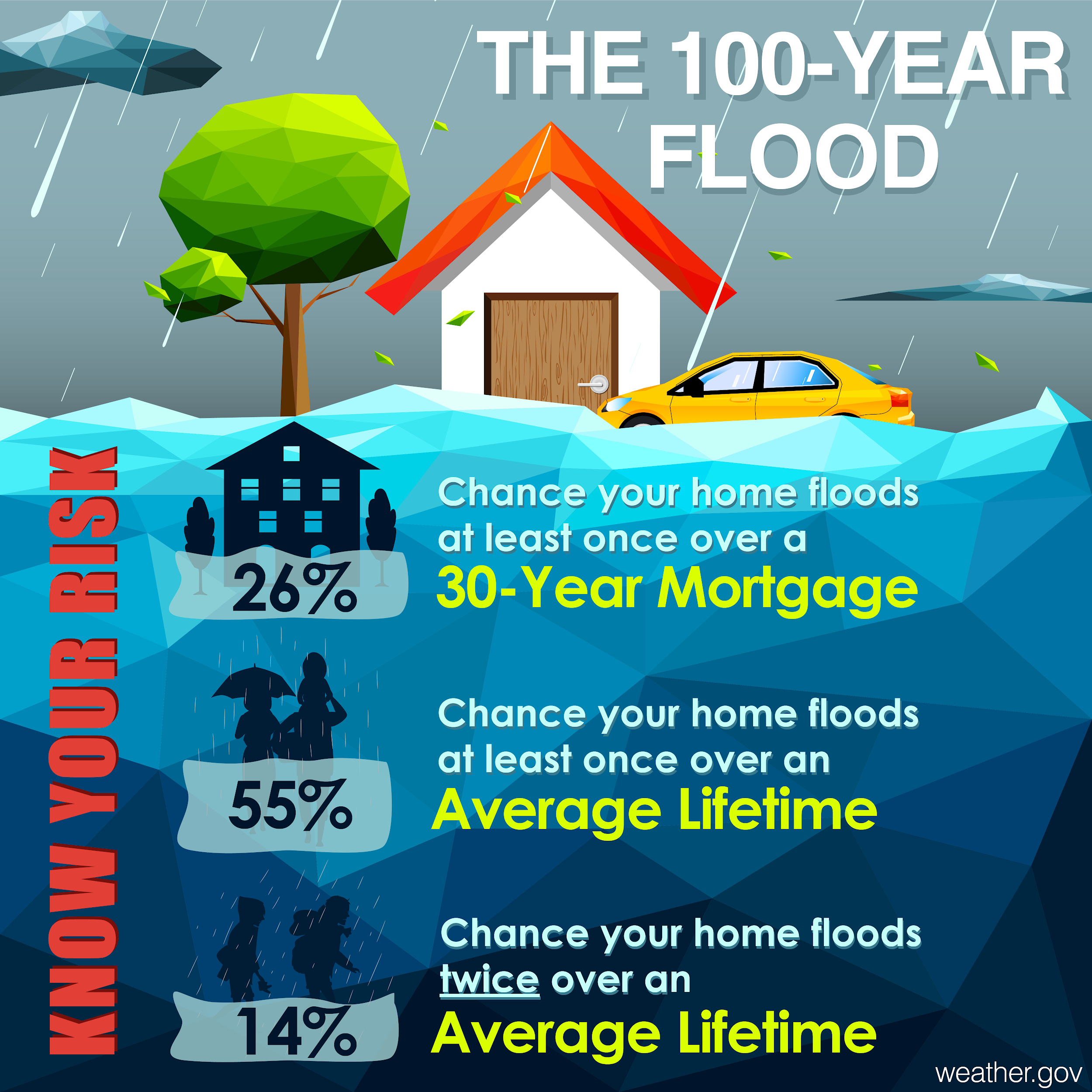
So, what does the term “100-year flood” actually means and how does it affect property and flood insurance coverage? The 100-year flood zone is a designated area that has a 1-in-100 chance (or 1% chance) of flooding in any given year. This also means it can flood more than once within a 100-year period and can even flood more than once in the same year. The 100-year flood is synonymous with several other terms, including Base Flood, 1% Annual Chance Flood, High Risk Flood Zone and Special Flood Hazard Area (SFHA). The 100 year-flood zone is any zone containing the letters “A” or “V.” When your structure is within one of these 100-year flood zones, flood insurance is REQUIRED by FEMA.
Structures and/or properties located in any part of a Special Flood Hazard Area (high-risk flood zone) have a 26% chance of flooding during the life of a standard 30-year mortgage. Never underestimate your true risk! And remember, flood risk CAN and DOES change over time. In fact, FEMA is constantly updating maps all over the country. When new maps are issued, your risk may have changed, along with your flood insurance requirements.
Protect Yourself. Consider flood insurance if you are close to a Special Flood Hazard Area. Do not ignore flood insurance, even if you are far from a high-hazard flood zone. FEMA statistics state that 25-30% of all flood insurance claims are paid in moderate-low risk areas.
You may also confirm (or challenge) your flood zone status but obtaining a flood determination report. This report provides information about a specific property or structure (home, office, storage facility, etc.) and confirms the location in correlation to the flood zone. Reports are generally low-cost and available via online service providers.
FEMA Glossary Terms. See more at https://www.fema.gov/about/glossary
100-year Flood Zone: Synonymous with Base Flood, 1% Annual Chance Flood, High Risk Flood Zone and Special Flood Hazard Area (SFHA). A designated area that has a 1-in-100 chance (or 1% chance) of flooding in any given year. This also means it can flood more than once within a 100-year period and can even flood more than once in the same year. The 100 year-flood zone is any zone containing the letters “A” or “V.” When your structure is within one of these 100-year flood zones, flood insurance is REQUIRED by FEMA.
Base Flood: A flood having a one percent chance of being equaled or exceeded in any given year. This is the regulatory standard also referred to as the “100-year flood.” The base flood is the national standard used by the National Flood Insurance Program (NFIP) and all Federal agencies for the purposes of requiring the purchase of flood insurance and regulating new development. Base Flood Elevations (BFEs) are typically shown on Flood Insurance Rate Maps (FIRMs).
Base Flood Elevation (BFE): The elevation of surface water resulting from a flood that has a 1% chance of equaling or exceeding that level in any given year. The BFE is shown on the Flood Insurance Rate Map (FIRM) for zones AE, AH, A1–A30, AR, AR/A, AR/AE, AR/A1– A30, AR/AH, AR/AO, V1–V30 and VE.
Flood Map: A Flood Insurance Rate Map (FIRM), Flood Boundary and Floodway Map (FBFM), and Flood Hazard Boundary Map (FHBM) are all flood maps produced by FEMA. The FIRM is the most common type of map and most communities have this type of map. At a minimum, flood maps show flood risk zones and their boundaries, and may also show floodways and Base Flood Elevations (BFEs). The FBFM is a version of a flood map that shows only the floodway and flood boundaries. The FBFM is no longer produced; current FIRMs include all of this information. The FHBM is an older version of a flood map and is based on approximate data.
More recent flood map products include digital FIRMs, which are created using digital methods and can be incorporated into a community’s Geographic Information System (GIS). FEMA has also produced Q3 Flood Data, which includes certain features of the FIRM, and may be used for insurance purposes and planning activities. The Q3 cannot be used as the official NFIP map for site design or flood risk determinations.
Flood Zones: Flood hazard areas identified on the Flood Insurance Rate Map are identified as a Special Flood Hazard Area (SFHA). SFHA are defined as the area that will be inundated by the flood event having a 1% chance of being equaled or exceeded in any given year. The 1% annual chance flood is also referred to as the base flood or 100-year flood. SFHAs are labeled as Zone A, Zone AO, Zone AH, Zones A1-A30, Zone AE, Zone A99, Zone AR, Zone AR/AE, Zone AR/AO, Zone AR/A1-A30, Zone AR/A, Zone V, Zone VE, and Zones V1-V30. Moderate flood hazard areas, labeled Zone B or Zone X (shaded) are also shown on the FIRM, and are the areas between the limits of the base flood and the 0.2% annual chance (or 500-year) flood. The areas of minimal flood hazard, which are the areas outside the SFHA and higher than the elevation of the 0.2% annual chance flood, are labeled Zone C or Zone X (unshaded).
ZONE A: No Base Flood Elevations determined.
ZONE AE: Base Flood Elevations determined.
ZONE AH: Flood depths of 1 to 3 feet (usually areas of ponding); Base Flood Elevations determined.
ZONE AO: Flood depths of 1 to 3 feet (usually sheet flow on sloping terrain); average depths determined. For areas of alluvial fan flooding, velocities also determined.
ZONE AR: Special Flood Hazard Area formerly protected from the 1% annual chance flood by a flood control system that was subsequently decertified. Zone AR indicates that the former flood control system is being restored to provide protection from the 1% annual chance or greater flood.
ZONE A99: Area to be protected from 1% annual chance flood by a Federal flood protection system under construction; no Base Flood Elevations determined.
ZONE V: Coastal flood zone with velocity hazard (wave action); no Base Flood Elevations determined.
ZONE VE: Coastal flood zone with velocity hazard (wave action); Base Flood Elevations determined.
Floodplain Management Plan
- 2018 Floodplain Management Plan
- FEMA Map Center – The FEMA Flood Map Service Center (MSC) is the official public source for flood hazard information produced in support of the National Flood Insurance Program (NFIP). Use the MSC to find your official flood map, access a range of other flood hazard products, and take advantage of tools for better understanding flood risk.
- Ordinance 2916: Flood Damage Prevention