Periodic delays should be anticipated in all project areas – please drive with caution. If you have any questions or concerns, contact City of Vestavia Hills Department of Public Services at 205.978.0150 or publicservices@vhal.org.
If you are experiencing issues with restoration following utility work being done at your residence or place of business, please submit your complaint via Vestavia Hills Connect (https://vhal.org/vestavia-hills-connect) or call 205.978.0150.
>Altadena Valley Park Trail Extension
Description:
Provide pedestrian connectivity between existing cart paths through the installation of new trails and the restoration or removal of deteriorated bridges.
Activity/Status:
Finalize design for path extensions and bid the project in summer of 2026. Complete bridge repair design in summer 2026.
Location:
Altadena Valley Park – https://maps.app.goo.gl/QK45Y59Nv2FEtt7H9
Managing Organization:
City of Vestavia Hills
Project Phase:
Trails – Design; Bridge Repair – Procurement of Design Services
Construction Start Date:
Fall 2026 (projected)
Construction End Date:
Fall 2027 (projected)
Estimated Cost:
$171,887 ($34,377 City)
City Participation:
City-led in compliance with ADECA requirements
Delivery Method:
City Forces/Public Bid – Grant-Funded Project (ADECA – RTP)
>Greendale Road Sidewalks
Description:
Provide a new sidewalk connection from Crosshaven Drive to East Street and install traffic calming improvements along Greendale Road. This project was prioritized due to high pedestrian activity as well as a traffic study that identified vehicle speeds exceeding targets set by the City’s Residential Traffic Calming Policy. Click HERE to view the project drawings.
Activity/Status:
Finalize design plans in summer 2026 and bid in fall 2026.
Location:
Greendale Road – https://maps.app.goo.gl/AauZHVz73kwto7iu8
Managing Organization:
Alabama Department of Transportation
Project Phase:
Design
Construction Start Date:
1st Quarter 2027 (projected)
Construction End Date:
December 2027 (projected)
Estimated Cost:
$958,754.89 ($191,750.98 City)
City Participation:
For TAP grants, the City serves as the project sponsor, providing the required 20% local funding match. The City manages the design and administers the bid and construction, in compliance with federal and state requirements.
Delivery Method:
Public Bid – Grant-Funded Projects (ALDOT – TAP)
>Highway 31 Gateway/Landscaping Project
Description:
Enhance the southern Highway 31 gateway to create a more welcoming, functional and visually appealing entrance into Vestavia Hills. Proposed improvements include:
City Signage: Installation of new “City of Vestavia Hills” lettering to complement the existing “southern temple” structure, along with a secondary “Vestavia Hills” sign featuring the city’s name and logo on the opposite side of Highway 31 near the Chevron station.
Stormwater Infrastructure Improvements: Upgrades to replace aged and damaged infrastructure and improve drainage, reducing ponding of water in the roadway.
Landscaping Enhancements: Installation of new landscaping within the US-31 center median, along with landscaping enhancements on both sides of the highway.
Retaining Wall: Construction of a decorative retaining wall (approximately 15’ tall x 130’ long) parallel to Highway 31 North. This feature will serve as visual backdrop for landscaping while also supporting future grading and potential development opportunities on the adjacent property.
The bid submitted by Gillespie Construction was accepted at the October 13, 2025 meeting of the City Council. Click to view the bid documents. Click here to view additional gateway and infrastructure project information, including the civil plans for the project. Revised drawings were shared with the Council at their regular meeting on 12/08/2025. Click HERE to view the revised drawings.
Activity/Status:
Construction of retaining wall, landscaping and signage features underway. Retaining wall construction temporarily halted due to delay in receipt of anchor bolts required for facade installation. Construction of retaining wall expected to resume the week of June 15, 2026 (weather permitting).
Location:
Highway 31 at I-65 – https://maps.app.goo.gl/qEA4rwPWUVmFddDFA
Managing Organization:
City of Vestavia Hills
Construction Start Date:
January 2026
Construction End Date:
Summer 2026 (projected)
Estimated Cost:
$1,222,872.70
City Participation:
City-led and funded
Delivery Method:
Public Bid – City-Controlled Project
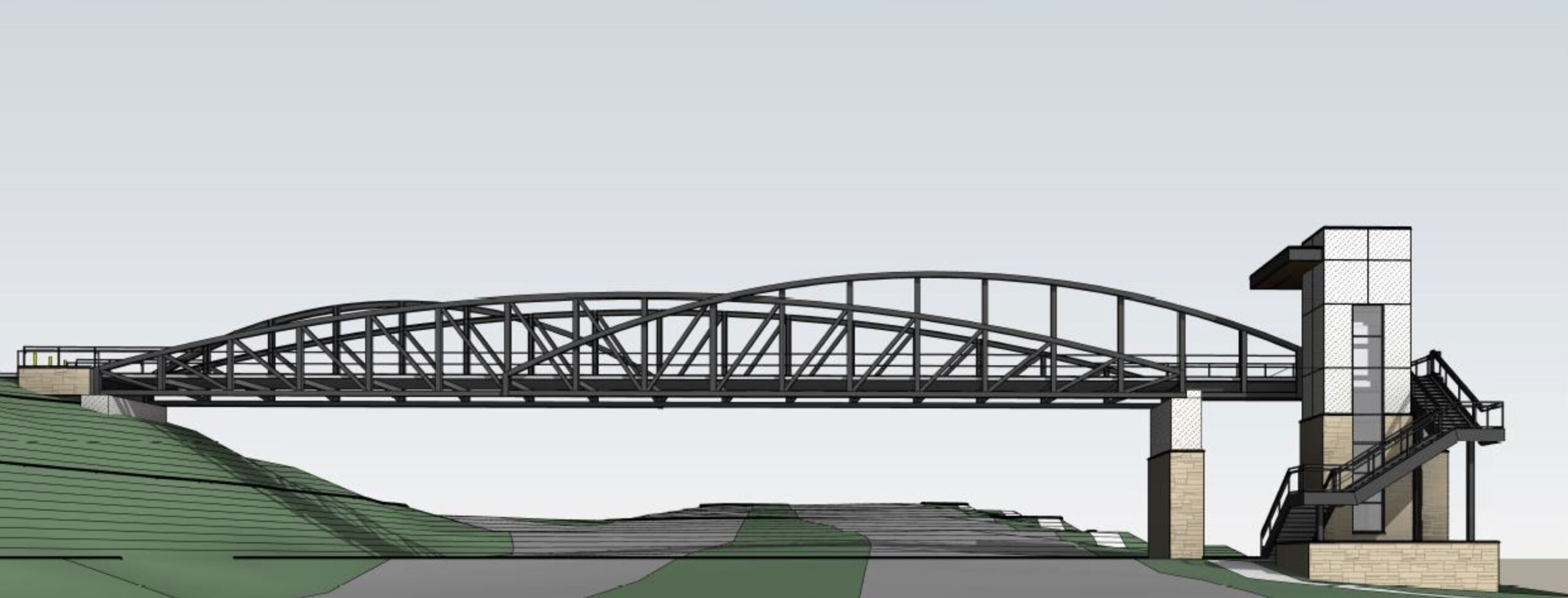
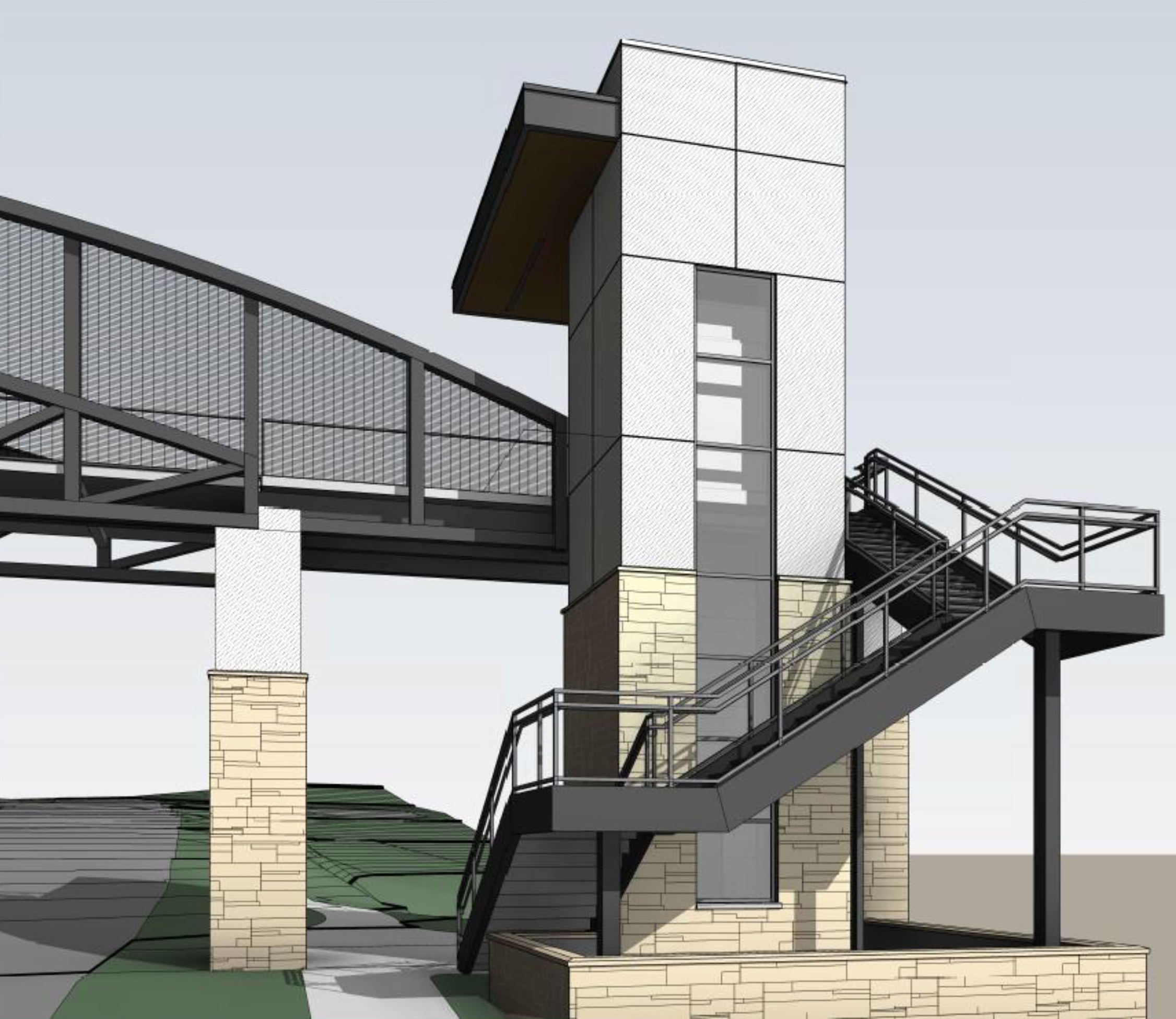
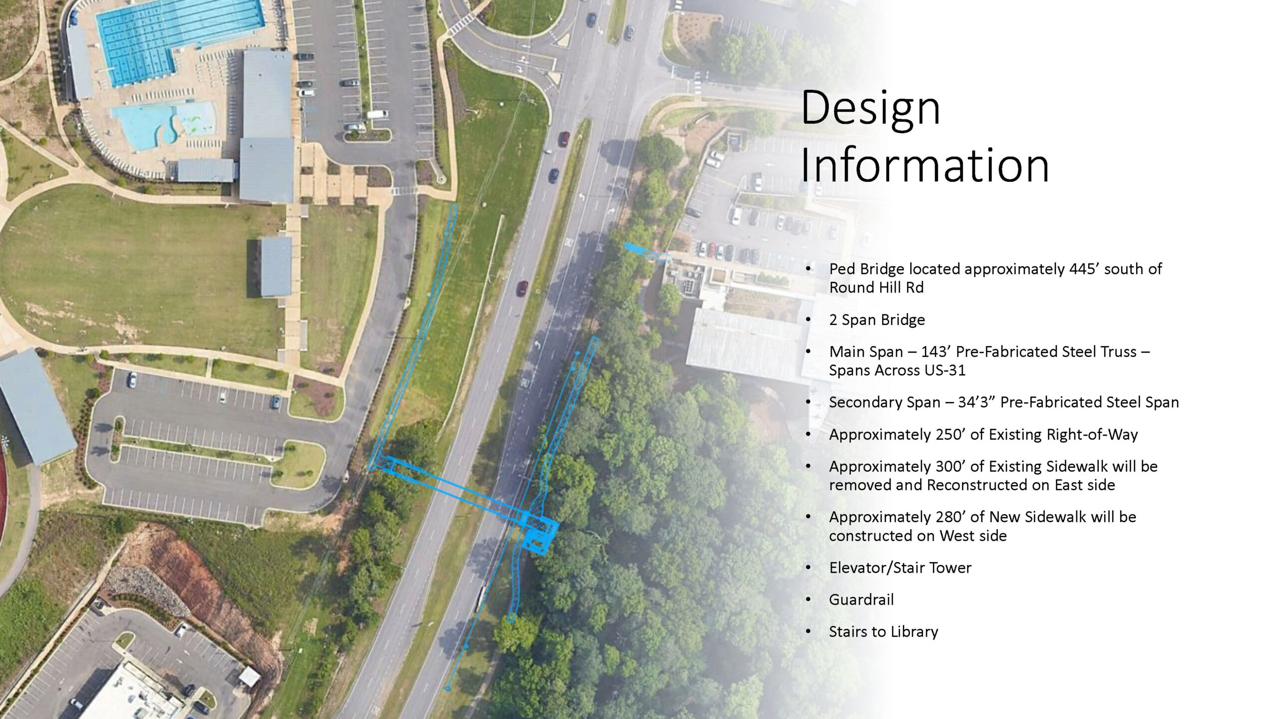
>Highway 31 Pedestrian Bridge
Description:
This project includes construction of a pedestrian bridge and adjacent sidewalk facilities to provide a safe pedestrian connection across Highway 31. The bridge will link to the existing sidewalk network, improving pedestrian connectivity to the City’s schools, library and parks while also improving the overall mobility and safety of pedestrians crossing this busy corridor. The project also includes utility relocations and construction of an elevator tower to ensure full accessibility. Click to view design rendering #1 and design rendering #2, as well as the design information and location.
Activity/Status:
Finalize window installation, elevator installation and complete sidewalk work around tower base. Per the schedule provided by ALDOT contractor, windows are projected to deliver the week of June 15, 2026; elevator installation to commence following window installation:
Glass installation: June 18-22, 2026
Elevator installation: June 23-July 3, 2026
Foundations & concrete installation: July 6-24, 2026
Block, veneer, stucco installation: July 6-31, 2026
Remaining item of work to be completed the month of August: completion of the enclosure; stairs on tower; concrete sidewalk tie-in; landscaping; and site clean-up.
Location:
1251 Montgomery Highway – https://maps.app.goo.gl/fYCjp4Kt3ALb2Si68
Managing Organization:
Alabama Department of Transportation
Construction Start Date:
August 2024
Construction End Date:
Summer 2026 (projected)
Original completion date extended due to material and shipping delays.
Estimated Cost:
$5,306,663.43 ($1,060,714.45 City)
City Participation:
The City serves as the project sponsor, providing the required 20% local funding match and coordinating with ALDOT to help ensure the project scope aligns with the City’s needs and priorities. ALDOT administers the bid and manages the construction contract.
Delivery Method:
Public Bid – Grant-Funded Project (ALDOT – CMAQ, DE, HPP & TAPBH)
>Highway 31 Pedestrian Bridge – Continuation of Sidewalk
Description:
Install sidewalk to provide connectivity from pedestrian bridge to existing sidewalk in front of Baumhower’s.
Activity/Status:
Coordination underway with ALDOT on approval of the sidewalk extension design.
Location:
1251 Montgomery Highway – https://maps.app.goo.gl/fYCjp4Kt3ALb2Si68
Managing Organization:
City of Vestavia Hills
Construction Start Date:
January 2027 (projected)
Construction End Date:
Summer 2027 (projected)
Estimated Cost:
$93,100
City Participation:
City-led
Delivery Method:
Selected Contractor – City-Controlled Project – Grant-Funded Project (Jefferson County Commission District Paving Grant Program)
>Liberty Parkway at Urban Center Parkway – Traffic Signal
Description:
Install a new traffic signal system to improve the safety of the Liberty Parkway and Urban Center Parkway intersection.
Activity/Status:
Coordination with Jefferson County team to procure materials, finalize details and establish start date.
Location:
Liberty Parkway at Urban Center Parkway – https://maps.app.goo.gl/VMdKnGYkcjFjxh6dA
Managing Organization:
Jefferson County
Construction Start Date:
Fall 2026 (projected)
Construction End Date:
Spring 2027 (projected)
Estimated Cost:
$235,000
City Participation:
City paid for design services and will pay $235,000 toward construction. Jefferson County to provide equipment, material and labor services.
Delivery Method:
Jefferson County Personnel – Joint/Partner Project (Jefferson County)
>Massey Road
Description:
Construction is underway following the prolonged resolution of a water main relocation issue. Project includes sidewalk improvements, drainage improvements, construction of a new retaining wall, shoulder improvements, roadway widening and asphalt resurfacing.
Activity/Status:
Wall construction to continue into summer 2026. Sidewalk installation to continue and final asphalt work scheduled for July 2026.
Location:
Massey Road (Highway 31 to Columbiana Road) – https://maps.app.goo.gl/3QQQYPFcWFYhT9xu7
Managing Organization:
Alabama Department of Transportation
Construction Start Date:
December 2024
Construction End Date:
Late summer 2026 (projected)
Original completion date extended due to delay in unforeseen water utility relocation.
Estimated Cost:
$6,085,399.69 ($1,217,079.94 City)
City Participation:
The City serves as the project sponsor, providing the required 20% local funding match and coordinating with ALDOT to help ensure the project scope aligns with the City’s needs and priorities. ALDOT administers the bid and manages the construction contract.
Delivery Method:
Public Bid – Grant-Funded Projects (ALDOT – CMAQ)
>Rocky Ridge Road at Dolly Ridge Road – Turn Lane
Description:
Add a northbound right-turn lane on Rocky Ridge Road to reduce congestion at the Dolly Ridge Road intersection.
Activity/Status:
Construction is underway
Location:
Rocky Ridge Road at Dolly Ridge Road – https://maps.app.goo.gl/WoBKRBNP3zTsfY9b6
Managing Organization:
Jefferson County
Construction Start Date:
Summer 2026
Construction End Date:
Summer 2026 (projected)
Estimated Cost:
Jefferson County to complete construction with County crews. City funded design (~$90,000).
City Participation:
City managed and funded design in collaboration with Jefferson County. Jefferson County acquired the necessary right-of-way and will complete the construction with in-house personnel.
Delivery Method:
Jefferson County Personnel – Joint/Partner Project (Jefferson County)
>Veterans Memorial Plaza
Description:
Construct a new Veterans Memorial Plaza featuring a pavilion, monument wall and hardscape elements. The project also includes landscaping, irrigation, and grading and drainage improvements to enhance the park and create a dedicated space for reflection and remembrance.
Activity/Status:
Construction is underway
Location:
Altadena Valley Park – https://maps.app.goo.gl/QK45Y59Nv2FEtt7H9
Managing Organization:
City of Vestavia Hills
Construction Start Date:
Spring 2026
Construction End Date:
Fall 2026 (projected)
Estimated Cost:
$477,329.50
City Participation:
City-led and funded
Delivery Method:
Public Bid – City-Controlled Project
2026/2027 Plan for Growth
The population of the eastern part of Vestavia Hills grew more than 1% from 2021 to 2023, with additional growth anticipated as several major developments in the Liberty Park area are completed and occupied. As such, a variety of capital projects are being considered to meeting the service demands this growing area. The bulk of the projects will be located in the area surrounding Sicard Hollow Athletic Complex – a former mine site that was recently redeveloped and revitalized as a part of the Pine Ridge Mine Reclamation Project funded by the Abandoned Mine Land Economic Revitalization (AMLER) program.
Proposed projects include:
-
- Addition/Renovation of Fire Station No. 4: Renovation and expansion of current Liberty Park fire station to reduce response times and accommodate call volume that has increased 140% in the eastern part of the City since 2011. Project underway.
- Access Road: Construction of a new road adjacent to SHAC. Proposed commencement: FY 2026.
- Public Works Maintenance Facility: To include storage bays for landscaping and repair materials, along with covered storage for maintenance equipment. Following completion of the new facility, the existing structure that currently faces Sicard Hollow Road will be demolished. Additionally, the road traversing the existing facility will be reworked to improve access to the Liberty Park Sports Complex. Proposed commencement: FY 2027.
- Library/Community Center: Community center or branch of the Library in the Forest to be built directly adjacent to Sicard Hollow Road, near the splash pad and pedestrian tunnel. Proposed commencement: FY 2027.
- Police Substation & Training Center: Construction of a new facility to accommodate increasing call volumes and reduce response time. Facility will additionally serve as a training center for VHPD. Proposed commencement: FY 2027.
- Liberty Park Field Improvements: Considering conversion of baseball and/or softball fields to artificial turf. Proposed commencement: FY 2027.
- Veterans Memorial: Bids for the construction of a veterans memorial at Altadena Valley Park were reviewed November 2025 and will be formally presented at a future Council meeting for consideration. For more information, visit https://vhal.org/vhprf. Proposed commencement: FY 2026.
- Pool Heater: Addition of a pool heater to extend the Aquatic Complex swim season. Project underway.
Click to view the 2025 Capital Improvement Priorities presentation and the Growth and Needs presentation shared during the 2025 Strategic Planning Session of the City Council.
Drainage Projects
Pipe Preservation Bid – preparing to bid summer 2026
Oakview Lane (final phase) – complete
Canyon Road & Pine Street Improvements – preparing to bid fall 2026
Jacobs Road (Phases I – III) – construction of Phase I underway
Vesthaven Way (culvert replacement) – design
Blue Lake Drive Drainage Pipe Replacement – construction planned for summer 2026
Upper East Highway 31 Masterplan – design of eastern trunkline scheduled for summer 2026
Click to View Current Drainage Studies & Project Information
Pavement Management Program
First Step Pavement Management evaluates the City’s streets on a three-year cycle, with the most recent assessment completed in 2025. Using video inspections, each street is assigned a Pavement Condition Index (PCI) rating based on the type, quantity and severity of pavement distresses observed. The PCI scale ranges from 1 to 100, where 100 indicates excellent condition, and any score below 45 is considered failed. Paving priorities are determined based on PCI ratings, field inspections, and geographic distribution to ensure an effective, data-driven maintenance approach.
2026 Paving List (calendar year) & Resolution 5190: Rebuild Alabama Act
Current Locations (work to begin July 7, 2026):
Countrywood Lane
Old Oak Lane
Old Oak Circle
Timberline Way
Cantebury Circle
Gresham Drive
Magnolia Ridge
Countrybrook Lane
Estimated Annual Cost: $581,245
Sidewalk Masterplan
The City of Vestavia Hills continues to install sidewalks to improve pedestrian connectivity and has developed a multi-year sidewalk masterplan to guide future pedestrian projects to further connect the citizens of Vestavia Hills to the commercial areas and gathering spaces throughout the City.
Click to view the current Sidewalk Masterplan and Resolution 5122: Sidewalk Construction Policy
Note that commercial districts along Highway 31, Rocky Ridge Road, Cahaba Heights Road, Crosshaven Drive and Green Valley Road have sidewalks shown on both sides of the road to provide additional walkable access to these areas. Future sidewalks shown in Liberty Park are based upon masterplan information provided by Liberty Park Joint Venture. Future pedestrian elements to provide further connectivity are currently being studied and evaluated.
Progress Videos
Click the links below to view recent progress videos for each project:
> Altadena Valley Park
> Highway 31 South
> Medical Properties Trust
> Sicard Hollow Athletic Complex
> The Bray at Liberty Park (commercial & residential)
> Wald Park
Click for more information regarding the Infrastructure & Community Spaces Plan
Planning Projects
- Traffic Operations APPLE Study (Phase 1)
- APPLE Potential Intersection Study
- Dolly Ridge Road & Rocky Ridge Road (Jeff Co) – currently signalized; review signal operations and potential turn lane additions
- Sicard Hollow Road & Blue Lake Drive (Jeff Co/Bham) – not currently signalized; review for safety, operational and sight line improvements
- Shades Crest/Rocky Ridge Road/U.S. Highway 280 (Jeff Co/ALDOT) – currently signalized and coordinated with U.S. 280 system; capacity analysis
- Highway 31 & Shades Crest Road (ALDOT/Jeff Co) – currently signalized; review signal operations and potential turn lane additions
- Highway 31 & Columbiana Road (ALDOT/Jeff Co) – currently signalized; review signal operations and operational improvements
- Highway 31/Old Creek Trail/Leona Way (ALDOT) – currently signalized; review signal operations, operational improvements with access management
- Columbiana Road & Shades Crest/Vestaview (Jeff Co) – currently signalized; pedestrian access
- Highway 31/City Hall/Sprouts (ALDOT/Jeff Co) – currently signalized; pedestrian access
- Highway 31/Pizitz Drive (ALDOT/Jeff Co) – currently signalized; pedestrian access
- River Run Drive & River Run Trail (Jeff Co/Bham) – not signalized; analysis for need to add 3‐way stop or other means of traffic control
- Jacobs Road & Massey Road (City of Vestavia Hills) – not signalized; review safety and sight line improvements, right‐of‐way constraints
- Acton Road APPLE Grant (Feasibility Study) – in design phase
- Wald Park Master Plan – awaiting Community Spaces Plan approval by Council
- Crosshaven APPLE grant – for more information, visit Crosshaven Drive Corridor Study
- East Street Analysis and Planning – for more information, visit East Street Data Collection Summary